Ambracian Gulf
As we descend from the coasts of Epirus to those of mainland Greece, we are suddenly confronted with a geological paradox. The compact coastline is cleaved by a narrow strip of sea, creating the most exciting “landlocked embayment” in the country. It is the result of intense tectonic activity, which began 2 million years ago. It is a tectonic draft which began to fill with the deposits of the two rivers, Arachtos and Louros. The rising sea level over the past 10,000 years resulted in the entrance of the Ionian Sea and the flooding the gulf from Aktion and Preveza, giving it its present form. The Amvrakikos Gulf penetrates a large part of land, occupying an area of approximately 405 square kilometers.
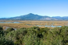
The vast Amvrakikos wetland was created by the two big rivers that flow into the gulf, Arachthos and Louros. The age-old action of these two rivers has contributed to the formation of an extremely complex and unique wetland in Greece; a remarkable variety of habitats, constantly changing, where outstanding beauty unfolds.
The Amvrakikos Gulf consists of at least 20 enclosed lagoons, a number nowhere to be found in any other part of Greece. Their total area exceeds 70 square kilometers, and most of them are separated from the sea by a long and narrow strip of land. When observing this strip of land from afar, you get the impression that it is made of sand. However, when you bend down on the ground, you will be surprised to find that it consists of countless clam shells.
The natural openings on these strips of land allow the lagoons to communicate with the sea and this is where the fishermen of Amvrakikos have installed the so-called “ivaria” or “divaria” many years ago, which are special reed constructions that allow the free passage of fish from the sea but prevent them from returning, thus leaving them trapped.


